Coordinates: 46°30’04″N 8°17’38″E 1350m ASL
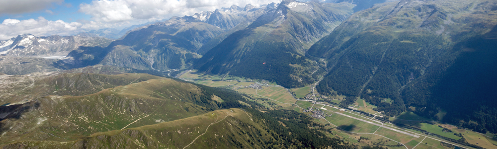
The panoramic image at the top of this page shows the Rhône glacier and Furka pass on the far left, Oberwald at the head of the main valley, the Agenetal (the valley which leads up to the Nufenenpass and Griespass from Ulrichen) just right of centre, and the landing field, next to the disused airstrip, in the lower right corner.

Ulrichen landing field from the south-west, with Münster in the foreground
This landing field is located halfway between Ulrichen and Geschinen, and is bordered by the main road along the valley and the westerly end of the disused airstrip. There is usually a windsock to help you identify it from the air, and the valley breeze in the afternoon is likely to be coming from an easterly direction. Usually, the wind at ground level is caused by the Grimseler, in which case it may be quite strong, particularly in the afternoon, though usually laminar. Beware of this landing field when there is south overpressure, as this can cause föhn to flow down the Agenetal, resulting in significant turbulence here.

Ulrichen landing field from the north-west, with the Nufenenpass on the left
If I am landing in this area, I usually choose the easterly end of the airstrip, as this is conveniently close to Ulrichen station, and there are plenty of wind indicators there. However, this is not an officially recognised option, and you are very much more vulnerable to turbulence due to wind from the Agenetal, as is obvious from the image above.
There are no official landing fields further to the east in the Goms. Although I have sometimes landed at Oberwald when 100% confident that the wind there was light, the Grimseler is often blowing at over 40 km/hr here from midday onwards. Also, in southerly conditions a breeze can flow down the Geretal directly into Oberwald and clash with winds from the Agenetal and/or main valley, so this would only be a reasonable choice if you are certain, because you have been keeping an eye on readings from all the nearby wind stations, that it would be quiet there.