“Overpressure” (a term used to refer to differences in atmospheric pressure) is relevant to the winds around Fiesch, and quite often mentioned by locals when discussing safety, hence the inclusion of this page here.
Having learned to fly in the flatlands of the south of England, I was taught to expect winds blowing more or less parallel to the isobars because of the coriolis effect, with their speed increasing with height due to the reduction in ground friction. However, I immediately discovered when I started flying in mountains that there is also a substantial extent to which air moves more directly along the easiest path from high to low pressure, and can be funnelled through more strongly lower down in narrow valleys than higher up, so it is vital to consider overpressure as well as the geostrophic flow here.
If you ask a regular Fiesch pilot for advice about the day’s flying conditions, they are likely to mention this parameter. Around here, the pressure difference in the north-south axis is considered to be the most important, and the measurements which are being referred to are those from Lugano (to the south) and Zürich (to the north). So if you hear that there is “2 hPa of south overpressure”, you are being told that the value (adjusted for the different heights of the weather stations) is 2 hPa higher in Lugano than in Zürich. A chart predicting the figure is available at Profiwetter:
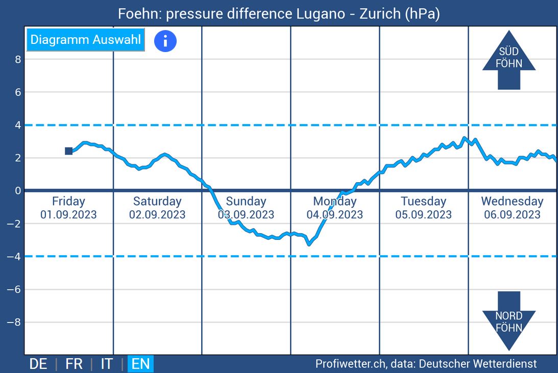
As you may have inferred from the text on the chart, the most significant feature generated by overpressure is föhn. It is also associated with the tendency of other winds, such as the Grimseler, to arise from side valleys. Another potential negative effect is the production of leeside downwashes, often particularly noticeable on south-facing slopes in north overpressure. Finally, the higher the value, the more likely it is that the air will feel generally disturbed and challenge your active flying skills.
Overpressure arises in axes other than north-south. A chart showing differences between a variety of locations (and hence directions) can be found at Wind und Wetter:
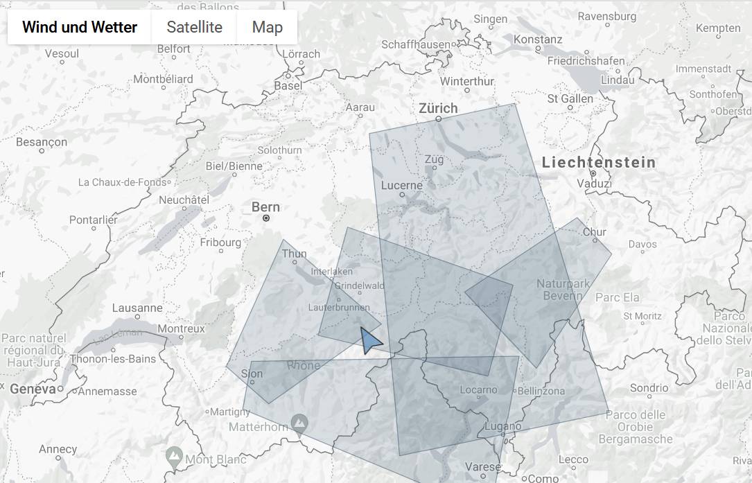
Wind und Wetter pressure differences chart (on the web page itself, click on each shaded area for details)
Another complication is that the pressure differences at ground level (which can easily be measured) may well not correspond to those at different heights (which are generally derived by weather models and difficult to ascertain), especially on days with inversions. In August 2024, there were several consecutive days with north overpressure measured between Zürich and Lugano but substantial south overpressure at higher altitudes, which produced turbulence and unexpected winds around Fiesch.
Variations of temperature and humidity between different airmasses can also affect the manifestations of overpressure, and the time of year also seems to influence the intensity of its effect. Also, it is estimated that the heat low associated with vigorous thermic activity on a good day may generate up to 3 hPa of negative pressure above the middle of the main valley, boosting the gradient on the lee side whilst inhibiting it on the windward side. This explains why it is sometimes possible to escape from generally rough air on one side of the valley by crossing to the other.
To fly safely around Fiesch, you should at least be aware of the expected value of this parameter because of its association with strong valley winds. It is often stated (and implied by the dotted lines on the Profiwetter chart) that 4 hPa is some sort of threshold for föhn, but this is a dangerous oversimplification and not borne out by experience. As with all weather phenomena, predictions often do not correspond to reality, and other effects may combine to reinforce or counteract the consequences of individual meteorological factors.
North overpressure can bring
- turbulence and downwashes on the south-facing side of the valley
- a strengthening of the winds from the north such as the Grimseler and Urserntal valley breeze
- an increased risk of malignant conditions around the Fiesch landing field
South overpressure is associated with
- south föhn
- the sudden breakthrough of turbulent outflows from valleys to the south
- easier progress on long XCs to the east due to the inhibition of disruptive northerly effects
The degree to which overpressure may affect the flying conditions is not easy to predict, but for a given figure it is likely to be more severe earlier in the season than later. I would be apprehensive around Fiesch if the figure exceeded 2-3 hPa in the spring, but even 4-5 hPa in August may have only a mild effect, and I once had a nice flight in October when it was 7 hPa. However, in order to anticipate dangerous valley winds it is much more important to check out accurate high resolution forecasts of airflows at various altitudes, e.g. those on XCTherm, than to rely solely on predictions of overpressure taken in isolation.