You can find details of the expected airflows and wildlife protection zones in the Surselva on the local club’s website. The main feature is that the valley breeze is nearly always an easterly (and usually strong in Chur) unless overpowered by a significant large-scale effect, such as a substantial meteo wind between south and west, or föhn.
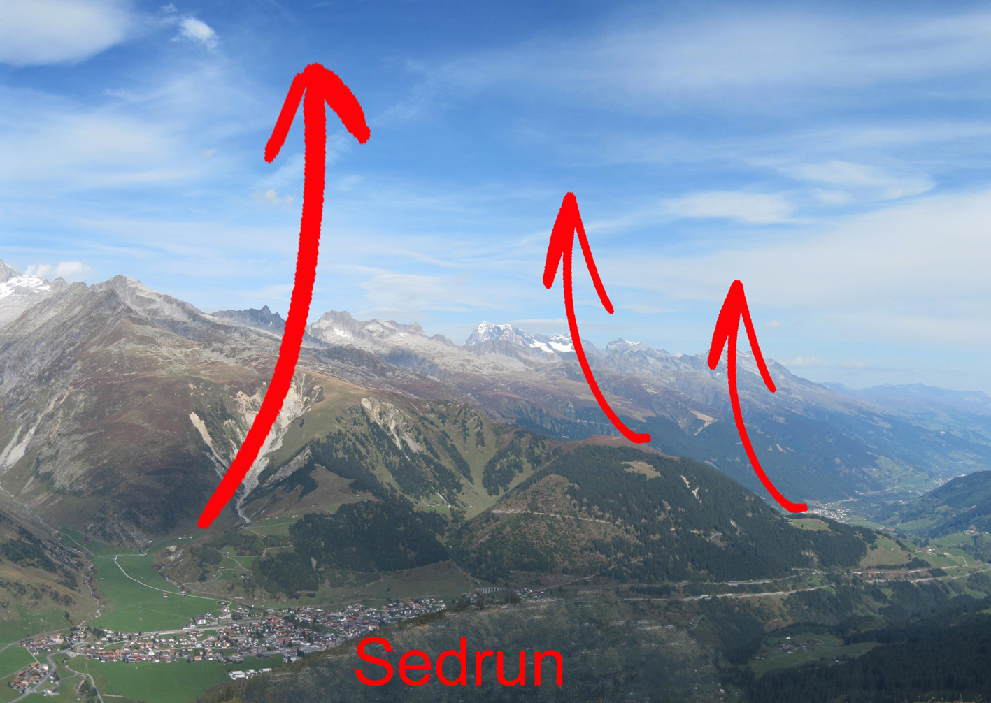
Once past the Oberalppass, you have surmounted the two major hurdles on the classic 120km route to Chur, though you are still not quite half way there in terms of kilometres. If I have scraped over without much ground clearance, I have usually found it beneficial to regain plenty of altitude as soon as possible. Sometimes the lift here seems rather ragged and I have wondered whether to hang on or keep going in the hope of something better ahead. When I have pushed on low, I have usually found good climbs just north or east of Sedrun, as shown in the picture below, i.e. funnelling up the landslide gully or (when that failed) releasing from the spine which sticks out across the main valley.
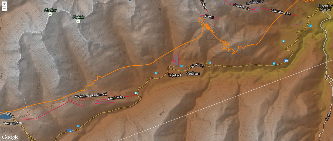
A few times, I have been able to maintain height in ridge lift here for a while before a good thermal came through, in which I was then able to get high again. The track log below shows how I needed to employ this tactic to remain airborne, having failed to connect with a decent climb in the first few km after coming over the Oberalppass. If you encounter a headwind before Sedrun, this is almost certainly due to a southerly outflow into Disentis from the Lukmanierpass via Val Medel (so probably föhn), not the normal easterly valley breeze, which is very unlikely to extend to sufficient height to reach this point.

Using the southwesterly facing slope beyond Sedrun (click here (and >> to 00:52:00 for 3D visualisation, here for XContest details)
One of the significant features of the Surselva, in contrast to the Goms and Urserntal, is the way that mountains like this stick out into any valley breeze, providing windward faces on which to survive or even soar up in between thermals if you get low (though of course there are then leeside areas of which you should be aware).
After Sedrun, the usual route is to stay on the south facing side of the valley, and when base is high enough for you to be able to get above the higher ground to your left, this should be the quickest way to make progress. A lower line over the sunny faces can feel less stressful, as the terrain appears kinder and landing options in the valley are nearer, but it is more likely to fail. The north facing side of the valley may work better, particularly later on and when the meteo wind is between north and west; this is likely if you came over the Oberalppass on that side due to northerly conditions around Andermatt. In fact, I would go as far as to say that the circumstances which led to you to choose that side in the first place mean that it will almost always work out better if you stay there rather than crossing back.
Around Brigels, the height of the mountains to your north declines; if these have been protecting you from a northerly airflow (either due to north overpressure or a heat low effect), you may see a sudden decline in the number, size, and duration of the convective clouds here, predicting generally descending air and a dramatic deterioration in thermic activity. In the worst case scenario, the north wind can break through significantly and flush you down into the valley, in which case you must avoid the airspace around the Tavanasa Heliport. The solution to this problem, provided that you have sufficient height, may be to cross to the other side of the valley, particularly if cloud development is better there. In Bise conditions (when you will have done well to have succeeded in crossing the Furka and Oberalp passes) a dearth of lift will probably also be accompanied by a headwind, as the Surselva provides a conduit for this northeasterly flow; you are then likely to struggle to reach Chur, as this will strengthen and increase in its height above the valley floor, the further you fly in this direction. Beware of flat areas in which a sinky downslope breeze can suddenly threaten your ability to glide out over tree covered terrain to a safe landing if you get low! In that situation, I would probably revise my route plan and turn around to try to retrace my steps. In that case, the landing field at Acla, near Disentis, is usually safe in northerly conditions until late afternoon, when you can expect a northerly downwash, but not the area of Tujetsch, nearer to the Oberalppass, as the north wind can break through here and only become apparent as a föhnish blast 50-100m above the ground.
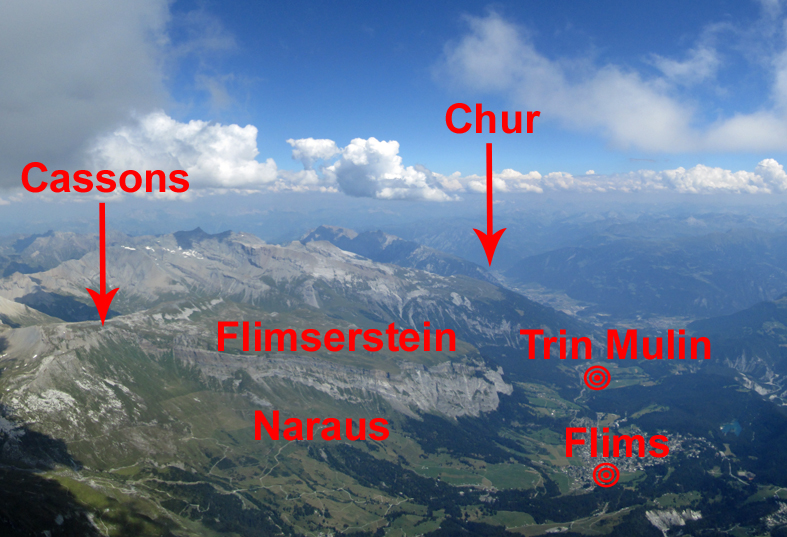
After Brigels, the popular flying area of Flims comes into view. The image above shows the location of the two takeoffs, Cassons (2670m) and Naraus (1850m), the landing fields at Flims (1100m) and 5km further on at Trin Mulin (800m), and the Flimserstein, which is a wildlife protection zone. This large inviting rocky face, an obvious thermal area, should not be overflown with less than 300m ground clearance. If you are interested in achieving round number milestones, the straight line distance from the Heimat takeoff to the Flims landing field exceeds 100km by a small margin!

Lower than normal route along the Surselva (click here for 3D visualisation, here for XContest details)
For the Surselva section of the visualisation, you can fast forward to 3:00:00. I am in a bit of trouble, low down before the Oberalppass, but I managed a low save to scrape over, and then minced along until connecting with the usual cracking climb just beyond Sedrun. Base was relatively low for this trip, at around 3,300m, so the subsequent route is lower and closer to the valley than ideal, rather than over the higher terrain further left, but I was able to reach Chur thanks to buoyant conditions under a cloud street extending from Disentis to Flims. However (see below) it was not a good idea to land down in the strong valley breeze.
A common obstacle now is the weather; if the conditions have been good enough to get this far, it’s not unusual for overdevelopment to present an impassable barrier before the task can be completed. The sky in the header image above was already giving me cause for concern, but less than 30km further on, as shown below, turning back was the only reasonable option. Alternatively, there may be extensive shading, or thermals starting to go off the boil due to the lateness of the hour, so you should be ready to change gear and fly more conservatively.
As you approach Chur, I recommend that you avoid goal fixation and stay high, because there is usually a vigorous north-easterly valley breeze there, even if you have been enjoying the assistance of a tailwind due to a general meteo flow from the west or south-west. If you get into this wind, it will not only impede your progress, but (as there are no windward faces available to enable you to turn it to your advantage) also lead to the likelihood of a landing in strong conditions, either in one of the inviting flat fields near the city itself, or a few km short where it is accelerated further by the valley narrowing. So you should not plan to land near Chur itself.

View of Chur, approaching from the west, showing the usual valley breeze, with the Schanfigg valley beyond
The most straightforward option (unless you want to keep going!) is to turn around once you’ve reached the Calanda (the mountain overlooking the town from the north-west), and fly back the way you came. There is a large landing area at Trin Mulin, 12km back, and 200m above the floor of the main valley, where the wind should be less strong, but the eastern end of this area can be turbulent due to a large cliff upwind of it, so fields to the west of the village are considered safer. The official landing field at Flims, around 15km from Chur, is well out of the main valley flow, as it is 500m above the valley floor, but the public transport connections from here are poor. However, this far from Chur, you can expect the breeze in the main valley to be much lighter, so if you arrive with a couple of hundred metres of altitude in hand, you may well be able to simplify your retrieve by flying down to land at Castrisch or Ilanz. The valley is quite wide there, and the wind is likely to be stronger than in Flims, but is usually laminar. It may even be possible to enlist the help of this valley breeze to bounce along either side of the valley all the way back to Disentis! Pilots who want to fly further than Chur usually continue to the east up the Schanfigg valley, and thence into Austria. A less popular alternative is to head north towards the Walensee. In westerly conditions, comp tasks from Disentis are often set with goal at Schiers.
The last train which takes the direct route back along the valley floor to Fiesch departs Chur at 17.55, passes through Ilanz at 18.33, with a connection in Disentis at 19.14, and arrives at 21.31. If you’ve missed that connection, you’ll need to go the longer way round, via Zürich, Bern, and Brig; the deadline to get back to Fiesch the same day using this route is 19.08 from Chur, arriving at 23.23. In the peak tourist season, hitchhiking back along the valley floor can work, but you may well get stuck when it gets dark, e.g. in Disentis or Andermatt, and need to find a bed for the night there.


