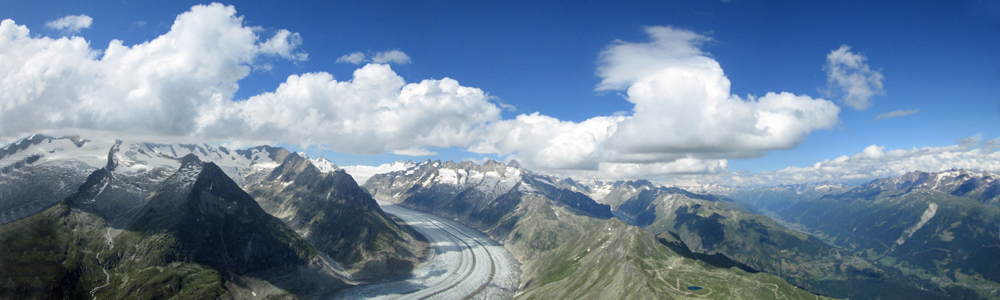
Using your smartphone

The use of a smartphone in flight to access online data – particularly current wind station readings – is popular amongst XC-orientated pilots in Switzerland.  I used to think this was ridiculously techy until I tried it myself, and discovered great benefits both in terms of safety and XC decision-making.  Here are three examples from my first month of using this facility:-

  • 13/8/23.  Approaching the eastern end of the Goms very low, and therefore concerned about getting rotored and flushed by the Grimseler, I could see that this wind was very weak and that there were upslope flows at the Sidelhorn and nearby, so continued in that direction rather than turning back.
  • 14/8/23.  With föhn forecast to develop later, increasing gusty wind values at Binn and Ulrichen (see image below) showed it had arrived earlier than expected, and led to a timely decision to land immediately, before conditions became dangerous.
  • 24/8/23.  Scraping over the Furka pass with less than 3,000m ASL, I could see that there were southwesterly winds in Andermatt and at Gütsch, indicating that without the usual headwind from the normal valley breeze, there was no need to prioritise gaining height, in anticipation of plenty of lift on what would therefore be a windward slope just beyond the village.

I use the web page widget in XCTrack Pro to display values from the nearest wind stations to my current position.  I turn this on before I launch, and then don’t need to touch the screen again during flight:

Windspion display in XCTrack Pro

Detailed instructions as to how to set this up can be found here.

This works for me because I am familiar with the geography of the area and therefore the position of these stations; for visitors, a map display such as SpotAir may provide a more helpful interface:

Spotair map display

A page on the Air3 manual has instructions on how to set this up.  You can zoom in and out, and tap on individual stations to access more detailed data there.

Winds.mobi is similar, includes more relevant stations, and is supposed to re-centre on your current position, but I don’t know if it’s compatible with XCTrack Pro:

Winds.mobi map display

The Burnair app (from which the header image on this page is taken) is quite popular among Swiss pilots, but it’s only available in German, and seems to be aimed at those who are happy with touch screen use in flight (which I prefer to avoid).  However, the map can be configured to show a wide range of relevant data as well as wind values, including airspace, thermal hotspots, known leeside areas, cables, landing fields, and even other pilots, colour coded to indicate whether in lift or sink!

Next season I intend to try expanding my use of XTrack Pro.  I have added a file containing all the thermal hotspots in Switzerland on thermal.kk7.ch (which you can download here) to the app’s waypoints folder, to assess whether this will help me find my next climb in areas with which I’m less familiar.

If you want to get a Swiss sim card to save on data roaming charges, I can recommend the Coop mobile prepaid sim (which is what I use).  At the time of writing (April 2024) this costs CHF 19.80 and comes with CHF 15.- of credit (which can be converted to 1500 MB of data).  Neither credit nor data has an expiry date, which is unusual.  My use of XCTrack for access to the wind station data plus live tracking consumes less than 4 MB per hour, but obviously other usage may be more data-hungry.  You can buy one of these sim cards at Fust and Inter Discount shops, as well as some Coop supermarkets; Swiss law requires photo ID to be shown, but foreign passports are accepted for that purpose.

Paraglidingforum members have recommended travel-dealz and digitalrepublic but I have no direct experience of either.